无人机飞行区域地貌识别技术研究与实现开题报告
2020-02-18 18:25:42
1. 研究目的与意义(文献综述)
| 1.1 研究目的及意义 近几年无人驾驶飞机(以下简称无人机)在低空、超低空等领域取得长足发展,运用范围也逐步扩大,机器也由高精尖向平民化迈进,催生了新兴运输等行业[1]。这便急需我们识别无人机飞行航线经过区域的地貌信息,对经过的区域的图像信息进行分类识别,从而对无人机的安全风险进行分析,为无人机航线规划提供依据,进行更加安全合理的无人机路径规划。 随着遥感技术不断发展进步,无人机获取的地貌图像越来越多,分辨率也越来越多,图像包含的信息更丰富,结构更复杂。遥感图像是按一定比例尺, 客观真实地记录和反映地表物体的电磁辐射的强弱信息, 是遥感探测所获得的遥感信息资料的一种表现形式。所以, 遥感技术应用的核心问题是根据地物辐射电磁辐射强弱在遥感图像上表现的特征, 判读识别地面物体的类属及其分布特征。遥感图像特征取决于遥感探测通道、地物光谱特征、大气传播特征及传感器的响应特征等因素。只要了解这些因素对遥感图像特征的影响, 则可按图像特征判读地面物体的属性及其分布范围, 实现遥感图像的分类识别。虽然已有许多分类方法被不同研究者提出[2],但由于遥感图像其同物异谱、异物同谱问题存在对场景分类带来了更大的挑战,使得大部分基于图像中低层特征分类的传统分类方法分类效果不太理想。而且,无人机工作在不同情景下对遥感图像处理要求截然不同,为了高效地分析和管理这些海量的遥感图像数据,使其应用到无人机地貌识别上,需要为图像添加准确有效的标签[3]。 文章中另一部分工作是建立无人机航行危险系数模型(SORA),为确保无人机地面控制系统可合理规划无人机群航线,需要我们对不同地貌建立危险系数,这样有助于将无人机更好的应用在运输等领域。 1.2 国内外研究现状 1.2.1 无人机图像处理 美国卡内基米隆大学对无人机系统中的关键问题进行研究,包括数据传输和图像处理等问题,并提出了针对无人机图像处理的解决方案,对无人机应用和发展产生了重要影响[4]。Kim[5]等人开发了无人机图像处理系统,用于无人机图像的二维、三维处理。Keller[6]等人在研究无人机图像处理中应用傅里叶变换,得到较为理想的图像配准结果。Kim[7]等人将无人机系统应用于制备检测,利用多光谱相机获取了研究区域的植被指数,并将该系统应用于快速方便的地面植被检测。 无人机遥感图像预处理是解译分析的重要保障,预处理过程主要包括图像配准、融合以及拼接等过程,Li Hui等人[8]提出基于边缘特征的多传感器图像配准方法,利用边缘特征匹配的方法对图像进行精确配准。田丹等人[9]将经验模态分解与互信息相结合进行图像配准。无人机遥感系统所获得的数据通常是单张的图片,为了获得研究区域完整精确数据都需对数据进行拼接校正。在遥感应用中首次出现图像之间的配准是P.E.Aunta等人提出的[10]。 场景分类是图像处理和计算机视觉领域研究热点之一,目前已取得了许多优秀的成果,大部分传统图像场景分类方法依赖于政府图像全局特征的提取,因此有效的特征表示对构建高性能的分类算法具有十分重要的作用。 1.2.2遥感图像分类识别 传统的遥感图像分类识别方法主要是基于像元的图像分类,图像的基本处理单元是单个像元。人们在这个框架下提出了很多新颖的遥感分类方法。最大似然法[11] 假设每个训练样本都是正态分布,通过有限的训练样本来估算整幅图像的方差和协方差,根据这些参数计算每个像元属于各个类别的概率,然后将像元划归为概率最大的类别;神经网络[12] 不需要基于任何统计假设,根据训练样本建立像元光谱属性和类别之间的黑箱模型,然后根据模型将每个像元划归为相应的类别;支持向量机[13] 构建一个超平面将像元按照其属性集划分为不同的类别。一系列新的算法正在被研制出来,并取得了很大的成果。随着遥感图像的分辨率不断提高,分辨率已经达到米级甚至是亚米级。对于传统的基于像元的遥感分类方法来说,Markham 等[14]认为遥感图像的空间分辨率的大小对图像分类精度影响的相反的两面性,分辨率的提高并不一定意味着遥感分类精度的提高。传统的遥感分类方法已经不能满足实际应用的需求。研究人员引入了面向对象方法,面向对象方法通过将光谱特证相似的像元合并在一起组成“对象”,进而根据对象特征进行分类识别,大大的提高了遥感影响分类识别的精度。 随着图像处理技术方面研究的不断提高,深度学习给遥感图像的分类识别提供了一种全新的视角。Chen 等人[15]在 2013 年采用深度信念模型训练高分辨率遥感图像,通过反向传播调整参数降低误差,准确的提取到图像中的飞机,取得了比传统方法更好的效果。Adriana等人[16]提出非监督的神经网络方法,这种方法利用 CNN 卷积层提取光谱矢量上的局部光谱信息,然后将提取到的特征图传到全连接层,最终完成高光谱遥感图像的分类。Chen 等人[17]提出用全卷积网络对 SAR 图像进行自动目标识别和分类,AR 数据集中达到了 99%的准确率。在 2017年,Grant[18]等人为了解决遥感图像样本不足问题,利用数据增强和迁移学习,再结合卷积神经网络,能够有效增加样本的数量和多样性。随着深度学习的发展,越来越多的深度学习算法应用于建筑物的提取、目标检测和土地利用的分类等领域中[19]。 遥感图像目标识别的一般流程包括特征提取、分类器训练和分类器判别三部分。第一步标注训练样本,并提取训练样本的特征;第二步设计分类器,并进行分类器训练;最后对图像进行目标检测,检测过程通常采用活动窗口的形式判断是否存在目标。目标检测常用的特征主要有 Haar小波特征[20]、梯度方向直方图[21]、局部二值模式[22]等。目标检测常用的分类器主要有最大似然法、支持向量机、马氏距离法和随机森林等。2014年 Girshick提出 R-CNN 模型,将深度卷积神经网络用于目标识别领域,然后不断出现基于卷积神经网络的目标识别算法,比如 SPP-Net、Fast R-CNN、FasterR-CNN、YOLO、SSD[23]等。这些方法大致可以分为基于区域的目标识别方法和基于回归的目标识别方法。基于区域的目标识别方法的核心思想是将目标识别转换成图像分类问题,基于回归的目标识别方法核心思想是将目标识别看作回归问题。 |
[U1]本部分的篇幅:不少于800汉字
2. 研究的基本内容与方案
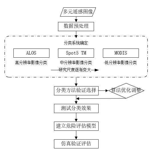
| 2、研究(设计)的基本内容、目标、拟采用的技术方案及措施[U1] 2.1 研究的基本内容和目标 本论文主要研究内容包括两部分,分别是无人机地貌分类识别,即遥感图像分类识别,利用现有传统分类方法—监督分类和非监督分类,与近年来出现的新的分类方法—人工神经网络和模糊分类,采用效果比较好的方法实现对无人机获取遥感图像识别分类,目标识别种类包括—居民区、商业区、道路、河流(水域)、绿地、裸地,并分析算法原理对其进行改进;另一部分为根据图像分类建立危险系数评估模型,针对无人机在不同类别土地上方飞行,可能会对下方造成某种危害程度,比如迫降、失控落地,对不同类别土地建立对应危险系数,建立航空规划最优方程,从而对无人机的安全风险进行分析,为无人机航线规划提供依据。 2.2 拟采用的技术方案及措施 本文研究内容主要是遥感图像识别分类和建立危险系数评估模型,根据老师建议和本人查阅文献,发现遥感图像识别分类主要分为以统计为基础的传统分类方法和与机器学习相结合的人工神经网络(Artificial neural net work, ANN)识别方法。宏观上,本文遥感图像分类采用人工神经网络方法进行分类,对其进行学习改进,辅之学习复现传统遥感图像算法和预处理,试图探索能否把传统遥感图像预处理和分类算法应用到机器学习的预处理上,从而找到创新点。 首先,按计划,在前四周学习传统遥感分类算法,无监督分类复K-means聚类算法。 均值分类方法(K-means算法)假定被用来表示样本空间的聚类中心的个数是预先知道的。这种假定本身在某种程度上限制了这一方法的利用。它使聚类域中所有样本到聚类中心的距离平方和最小,这是在误差平方和准则的基础上得来的。聚类中心数、初始聚类中心的选择、样本输入的次序,以及样本的几何特性等均影响平均算法的进行过程。对这种算法虽然无法证明其收敛性,但当模式类之间彼此远离时这个算法所得的结果是令人满意的。 监督分类算法复现极大似然分类方法,它利用遥感数据的统计特征,假定各类的分布函数为正态分布,在多变量空间中形成椭圆或椭球分布,也就是和各方向上散布情况不同按正态分布规律用最大似然判别规则进行判决,得到较高准确率的分类结果。否则,用平行六面体或最小距离分类效果会更好。 在第5周到第9周进行机器学习算法学习,主要以视觉词袋、特征编码、CNN 作为理论依据提取遥感图像的有效特征,再使用特定分类器执行分类任务。 由于遥感场景图像数据集规模的限制,使用遥感数据训练深度 CNN 是不现实的。现有的在自然图像数据集上训练好的 CNN 需要固定尺寸的输入,而遥感场景图像的尺寸与 CNN 需要的输入尺寸并不相同,虽然可以将遥感场景图像扩大或缩小成相同的尺寸,但是会损失很多信息。因此,本文使用滑动窗口提取图像的 CNN 特征,一幅图像划分成多个与 CNN 输入尺寸相同的局部区域,分别提取每个局部区域的 CNN特征。然后对获得的多个局部区域的 CNN 特征进行池化操作可以得到最终的图像表示。在某种程度上,池化是一种特殊的卷积操作,因此通过卷积操作来代替池化,能够得到更具有辨别力的特征表示。 当遥感图像识别分类任务完成后,第10周将进行无人机航行危险系数评估,针对在不同地貌无人机航行潜在风险建立危险系数,即设计其对应的权重,建立危险评估方程。并利用地面控制仿真对算法正确率进行验算。 2.3 毕设工作流程图
图2.1 毕设工作流程图 |
[U1]本部分的篇幅不少于400汉字,要图文并茂,技术方案至少包含一副图
3. 研究计划与安排
3、进度安排
第1-2周:查阅相关文献资料,明确研究内容,了解研究所需理论基础。确定方案,完成开题报告。
第3-4周:学习并实现遥感图像分类传统方法,监督分类实现极大似然分类算法,非监督分类实现k-means分类算法,比较其性能。
4. 参考文献(12篇以上)
| [1]付郑语. 无人机高空图像的识别技术[J]. 电子技术与软件工程, 2018(2):77-77. [2] Linder T , Zamir R .High-resolution source coding for non-difference distortion measures: therate-distortion function[J]. IEEE Transactions on Information Theory, 1999,45(2):533-547. [3] Chaib S , Liu H , Gu Y , et al. DeepFeature Fusion for VHR Remote Sensing Scene Classification[J]. IEEETransactions on Geoscience and Remote Sensing, 2017, PP(99):1-10. [4] Doherty P,Granlund G H, Kuchcinski K, et al. The WITAS unmanned aerial vehicle project[C]//Whorn: Ecai European Conference on Artificial Intelligence. 2000:747--755. [5] Kim J, LeeS, Ahn H, et al. Feasibility of employing a smartphone as the payload in a photogrammetric UAV system[J]. Isprs Journal ofPhotogrammetry amp; Remote Sensing, 2013, 79(4):1-18. [6] Keller Y,Averbuch A, Israeli M. Pseudopolar-based estimation of large translations, rotations, and scalings in images[J]. IEEETrans Image Process, 2005, 14(1):12-22. [7] Kim Z W,Gomes G, Hranac R, et al. A Machine Vision System for Generating Vehicle Trajectories over Extended Freeway Segments[J].World Congress on Intelligent Transport Systems, 2008. [8] Li H, ZhouY T. Automatic EO/IR sensor image registration[C]// International Conference on Image Processing, 1995. Proceedings. IEEE,1995:240-243 vol.3. [9] 田丹, 高强, 赵振兵,等. 基于经验模式分解和互信息的图像配准研究[J]. 电力系统通信, 2009, 30(1):37-40. [10] Zhu Q, Zhong Y, Zhao B, et al. Bag-of-visual-words scene classifier with local and global features for high spatial resolution remote sensing imagery[J]. IEEE Geoscience and Remote Sensing Letters, 2016, 13(6):747-751. [11] Huang L, Chen C, Li W, et al. Remote sensing image scene classification using multi-scale completed local binary patterns and fisher vectors[J].Remote Sensing, 2016, 8(6): 483. [12] Benediktsson J A, Swain P H, Ersoy O K. NeuralNetwork Approaches Versus Statistical Methods In Classification Of Multisource RemoteSensing Data[J]. IEEE Trans. Geosci. amp; Remote Sensing, 1990, 28(4):489-492. [13] Huang C, Davis L S, Townshend J R G. Anassessment of support vector machines for land cover classification[J]. InternationalJournal of Remote Sensing, 2002, 23(4):725-749. [14] Zhu G, Dan G B. Classification using ASTER dataand SVM algorithms; : The case study of Beer Sheva, Israel[J]. Remote Sensingof Environment, 2002, 80(2):233-240. [15] M. Pal, P. M. Mather. Support vector machinesfor classification in remote sensing[J]. International Journal of Remote Sensing, 2015,26(5):1007-1011. [16] Markham B L, Townshend J R G. Land coverclassification accuracy as a function of sensor spatial resolution[J]. Proceedings ofInternational Symposium on Remote Sensing of Environment, 1981, 3. [17] Chen X, Xiang S, Liu C L, et al. AircraftDetection by Deep Belief Nets[M]. 2013. [18] Romero A, Gatta C, Camps-Valls G. UnsupervisedDeep Feature Extraction for Remote Sensing Image Classification[J]. IEEETransactions on Geoscience amp; Remote Sensing, 2016, 54(3):1349-1362. [19] Chen S, Wang H, Xu F, et al. TargetClassification Using the Deep Convolutional Networks for SAR Images[J]. IEEE Transactionson Geoscience amp; Remote Sensing, 2016, 54(8):4806-4817. [20] Scott G J, England M R, Starms W A, et al.Training Deep Convolutional Neural Networks for Land-Cover Classification ofHigh-Resolution Imagery[J]. IEEE Geoscience amp; Remote Sensing Letters, 2017, PP(99):1-5. [21] Weng Q, Mao Z, Lin J, et al. Land-UseClassification via Extreme Learning Classifier Based on Deep Convolutional Features[J]. IEEEGeoscience amp; Remote Sensing Letters, 2017, PP(99):1-5. [22] Alshehhi R, Marpu P R, Wei L W, et al.Simultaneous extraction of roads and buildings in remote sensing imagery with convolutionalneural networks[J]. Isprs Journal of Photogrammetry amp; Remote Sensing, 2017,130:139-149. [23] Chen X, Xiang S, Liu C L, et al. VehicleDetection in Satellite Images by Hybrid Deep Convolutional Neural Networks[J]. IEEEGeoscience amp; Remote Sensing Letters, 2017, 11(10):1797-1801. |
[U1]参考文献不少于15篇,其中近五年的外文文献不少于3篇


